
By Chanakya
Even as far back as in 1976, authorities knew that the pilgrimage hill town of Joshimath in Uttarakhand was sinking. A detailed study report had been made at that time, elucidating the reasons behind the town becoming unstable and dangerous. Several restrictions and ground management measures were given in the report.
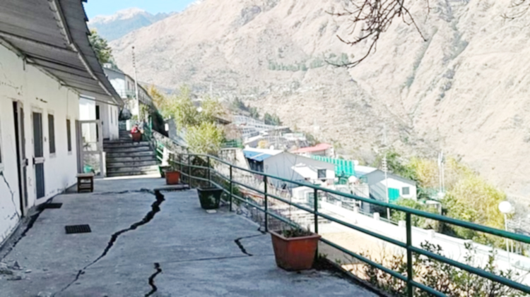
The MC Mishra committee (18-member) report kept gathering dust and no action was taken. Construction continued unabated, adding stress to the to the already unstable ground, till recently all hell broke loose. As of now over 700 buildings in ‘sinking Joshimath’ have developed cracks and ones that are most damaged will have to be demolished.
More than 4,000 people have been evacuated and shifted to safer areas, with much of the town expected to look like a ghost town soon. And all this, because of sheer human greed, constantly overlooking dangers that can result in a major crisis.
However, the story is of a bigger danger: according to a recent ISRO finding, all of Joshimath may just disappear into the depths of the Himalayas. While the natural loose rock surface was one reason, extensive construction work, to many brick and mortar houses and then the four-lane highways for the Char Dham project, as well as tunnels and, to top it all, the NTPC mega project, have purportedly rung the death knell of the hill town.
Relief work, as the government has initiated, is only a temporary effort. The complete destruction of the town has started and we, humans, are the ones responsible for it.
More to come
Incidentally, Joshimath is just one in the long line of Indian hill towns and cities that have so burdened the environment that Mother Nature seems to be hitting back with a vengeance.
Just like Joshimath, several other towns in the foothills of the Himalayas are vulnerable to ground subsidence. If things are not controlled, Nainital, Dharchula, Mussoorie, and several other towns in Uttarakhand might face a similar situation soon.
A geological study around Nainitalby researchers from Wadia Institute of Geology and Graphic Era Hill University also found similar implications in 2016. The study confirmed that the area dominantly comprises limestone with shale and slate which are highly crushed and weathered due to the presence of the Nainital Lake Fault. “These rocks and the overlying soil have very low strength,” the study found.
An unlikely town
Joshimath, which started as a small pilgrim town, is called the “winter seat” of Lord Badrinath, whose idol is brought down from the main Badrinath temple to Vasudeva temple in the town every winter. It is also the gateway to the Sikh holy shrine Hemkund Sahib. This religious over-pressure has resulted in a town, which should not have been there is the first place, that might have to be completed evacuated and then sinks to its total destruction.
As of now the official decision is that very damaged buildings will have to be demolished to protect adjoining buildings. Residents have protested this, arguing over the compensation levels. The government has allotted a measly Rs 1.5 lakh for those preliminarily displaced, and if this is any indicator of the level of compensation being thought of, then the residents have a bad deal in their hands.
In this chilly winter, displaced people are being forced to sleep outdoors in the freezing cold in fear of an imminent collapse of their houses – too many have developed huge cracks.
The 3 critical zones
Initial damage estimates have been hasty, with the state government and the NDRF having divided Joshimath into three zones: ‘Danger’, ‘Buffer’, and ‘Completely Safe’. These have been based on the magnitude of danger from land subsidence or the sinking or settling of the ground surface.
Over 700 buildings in ‘sinking Joshimath’ have developed cracks, officials said. The ones that are most damaged will be demolished. For those shifted out of their houses, “Basic facilities in the relief camps arranged and are being constantly inspected by the administration and all possible help is being extended to the affected people,” according to Chamoli district magistrate Himanshu Khurana.
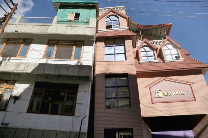
“Under the Disaster Management Act, 2005, Hotel Mount View and Malari Inn have been banned for operation and accommodation, until further orders,” the Chamoli District Disaster Management Authority said in a statement. The two hotels will be demolished.
The old report
Almost 50 years ago, the Centre had appointed MC Mishra, the then collector of Garhwal, to look into why Joshimath was sinking. The report submitted by the 18-member committee could not have been more prophetic. It clearly explained that Joshimath was situated on an old landslide zone and could sink if development continued unabated, and recommended that construction be prohibited in Joshimath.
Joshimath lies on an ancient landslide, resting on a deposit of sand and stone, not rock. The rivers Alaknanda and Dhauli Ganga play their part in triggering landslides, by eroding the river banks and mountain edges. It’s believed that increased construction activity and growing population have contributed to frequent landslides in the area, the 1976 Mishra Committee Report had pointed out.
“Joshimath is a deposit of sand and stone; it is not the main rock hence it was not suitable for a township. Vibrations produced by blasting, heavy traffic, etc., will lead to a disequilibrium in natural factors…” the report has stated.
Lack of proper drainage facilities also leads to landslides. The existence of soak pits, which allow water to slowly soak into the ground, is responsible for the creation of cavities between the soil and the boulders. This leads to water seepage and soil erosion, the report had said.
Residents have said they wrote to the chief minister thrice last month, alerting him about the impact of the blasts in the tunnels of the National Thermal Power Corporation (NTPC) project. NTPC has denied any links between its project and the situation in Joshimath.
What the government has done
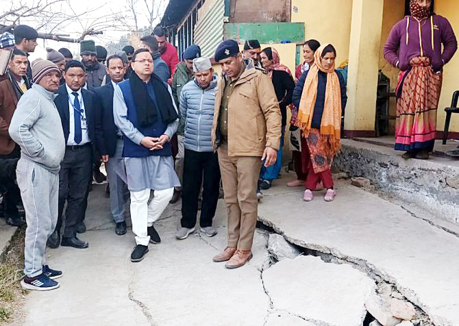
Chief Minister Pushkar Singh Dhami has appealed to everyone to work as a team and save the town. Prime Minister Narendra Modi has also assured full support to the state government. Officials from the Ministry of Home Affairs and the National Disaster Management Authority met Uttarakhand Chief Minister Pushkar Singh Dhami here to assess the situation in Joshimath and underlined the need for ascertaining the location of underground water accumulation in the subsidence zone.
“The Joshimath area has been declared disaster-prone. Two teams from the central government, including a team from the Jal Shakti ministry, are arriving here. Construction activities have been banned in Joshimath and nearby areas. Dry ration kits are being distributed to the affected people,” the Chamoli DM said.
The ongoing construction work under the NTPC’s Tapovan Vishnugad Hydroelectric Project has been stopped with immediate effect, till further orders.
Ho Hare Helang bypass construction work by the Border Roads Organisation (BRO) has also been banned with immediate effect, till further orders. “A ban has also been imposed on construction works being undertaken by the Joshimath Municipality, till further orders,” it stated.
In the Joshimath city area, 229 rooms have been temporarily identified as habitable, with the capacity estimated at 1271.
What scientists say
Dr C P Rajendran, adjunct professor at the National Institute of Advanced Studies, Bengaluru and an expert on seismo-tectonics and earthquakes, has frequently warned against the large scale infrastructure projects (66 tunnels and over 200 dams presently being built in Uttarakhand) that pose a major risk to the fragile ecosystem of this small hilly state.
Dr Rajendran has described the Char Dham road project as a ‘freeway to disaster’, fearing such unscientific road construction is having catastrophic consequences for the mountain ecology.
Not only have these engineering interventions resulted in a sharp acceleration in landslides, but he believes the construction of the 125 km long rail track from which 105 km will be tunnels is also adversely impacting the Himalayan mountain chain in terms of tectonics.
“There is a belief that building tunnels may decrease the infrastructural impact on the environment. But these subsurface structures could result in gross damage to the environment,” says Dr Rajendran.
“Rail traffic may rely on electric locomotion, but constantly generated vibrations during train movements is another issue related to tunnels that would lead to weakening rock formations further leading to landslides besides generating a huge amount of waste,” he explains.
Dr Rajendran warns that the Himalayan environment is on the “brink of collapse”.
“It may not be able to withstand another push generated by these intrusive anthropogenic activities in the form of massive projects like highways, railway tracks and dams.”
Garhwal geologist Dr S P Sati was among the scientists invited by the Joshimath Bachao Sangharsh Samiti to prepare a report in 2022 on the reasons why this temple town was sinking and what immediate steps must be taken to halt the process.
“Joshimath cannot be saved. It is too late,” Dr Sati says. “The entire public needs to be evacuated immediately. Any day, the entire town can collapse.”
“The government knew the town had been built on a moraine which are para glacial sediments that are not static. These moraines get mobilised due to heavy rainfall events. All our warnings against heavy construction on these unstable foundations went unheeded,” says Dr Sati
Kedarnath, Badrinath and several other towns in Uttarakhand, he adds, have all come up on moraines. The most immediate step that needs to be taken is to ban all construction activity. Prepare detailed plans for each of these towns to ensure they have proper drainage and sewage systems in place.
India’s collapsing hill stations
India’s hills stations are nearing tier use by date. Punishing water crisis, endless traffic jams, toxic vehicular pollution, mounds of litter, unchecked development and ad hoc construction are turning India’s summer retreats into unwelcome and unsustainable hot spots
Chilling out in a popular Indian hill station is no more a hot proposition.
Shimla, the legendary summer capital of the Raj, once famous for its meandering boulevards, English fruit orchards and walks lined with trees and flowers is a slum. Except for the random Gothic villa, it’s great verandah-fronted bungalows, Tudor cottages and picturesque chalets have been razed by indiscriminate building spree in the 1990s. An imperial city, which thrived on high society invitations, teas, strolls, picnics, dinners, balls, fetes, races and amateur theatricals, is in the grip of a tourist invasion from the plains, escaping the scorching summer heat.
The story is the same in Kasauli, Mussoorie, Ranikhet and other summer retreats. A reverse metamorphosis of sorts is happening to the hill stations: the beautiful butterfly has turned into an ugly caterpillar. Says author Ruskin Bond who has spent most of his adult life in Mussoorie, “These places survive on tourism. So tourists cannot be discouraged. I wish a little more attention is given to caring for the surroundings and encouraging sustainable tourism. We need tourism, but we also need to preserve the beauty and sanctity of the mountains.”
The ISRO report
The National Remote Sensing Centre (NRSC) of the Indian Space Research Organisation (ISRO) has released satellite images of Joshimath and a preliminary report on land subsidence which shows that the entire town may sink.
The Indian Space Research Organisation’s (ISRO) National Remote Sensing Centre (NRSC) released satellite images of Joshimath and the preliminary report on land subsidence showed that the entire town may sink, IANS reported. Hyderabad-based NRSC has released satellite images of areas that are sinking. The pictures are taken from the Cartosat-2S satellite.
The Uttarakhand government is conducting rescue operations in danger-prone areas on the basis of ISRO’s preliminary report. The government is shifting the people in these areas to safer places on priority.
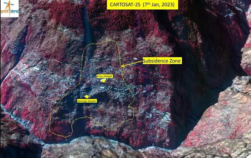
According to the report, the land subsidence was slow between April and November 2022, during which Joshimath had sunk by 8.9 cm. But between December 27, 2022 and January 8, 2023, the intensity of land subsidence increased and the town sank by 5.4 cm in these 12 days. The satellite images show that the Joshimath-Auli road is also going to collapse due to the land subsidence. Although scientists are still studying the cracks that appeared in the houses and roads after the land subsidence in the town, the findings in the primary report of ISRO are frightening
OTHER DISTURBING FACTORS
The NTPC’s Tapovan Vishnugad hydro power project: As per geologists, Joshimath will be at risk if the under-construction National Thermal Power Corporation (NTPC) Tapovan Vishnugad Hydro Power Project is not shelved. The plant, constructed on the Dhauliganga River in the Chamoli District of Uttarakhand, is expected to generate over 2.5 TWh of electricity annually.
Tourist and construction activity: Tourism and construction activities in Joshimath are of prime reasons why the town is sinking, as per experts. The town sees a footfall of lakhs every year, which is why the landslide-prone ground is facing instability.
Anthropogenic activities: Not just natural factors but also several anthropogenic activities have led to the subsidence of Joshimath. Kalachand Sain, Director of the Wadia Institute of Himalayan Geology said, “Hotels and restaurants have mushroomed everywhere. The pressure of population and the size of the crowd of tourists has also increased manifold,” he said. He also suggested that many houses in Joshimath are expected to collapse and residents have been asked to shift to safer locations.
Withdrawal of water: The phenomenon takes place when large amounts of groundwater have been withdrawn from certain types of rocks, such as fine-grained sediments, USGS suggested. The rock compacts because the water is partly responsible for holding the ground up. When the water is withdrawn, the rocks fall in on themselves.
Fragile ecosystem and seismic zone: Another reason can be Joshimath’s location in seismic zone V which is more prone to earthquakes. The gradual weathering and water percolation reduce the cohesive strength of the rocks over time. As per a study by the Mishra Committee in 1976, Joshimath, situated on an old landslide zone, could sink if development continued unabated. “Joshimath is a deposit of sand and stone — it is not the main rock — hence it was not suitable for a township. Vibrations produced by blasting, heavy traffic, etc., will lead to a disequilibrium in natural factors,” a report submitted by the 18-member committee said.


